The 10 Best Gps For Hiking, Tested And Researched
 By, Scott Nelson
Updated
The Quick List

Garmin eTrex 10 Handheld GPS
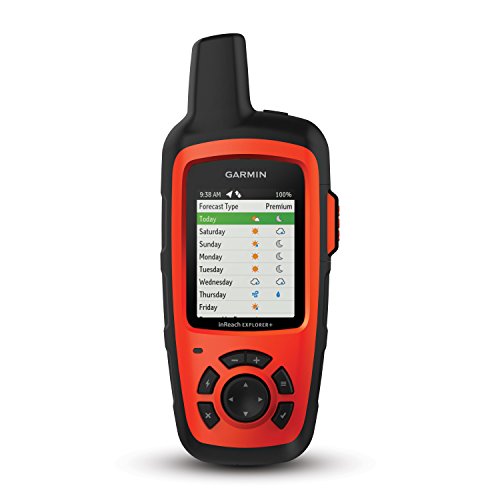
Garmin inReach Explorer+
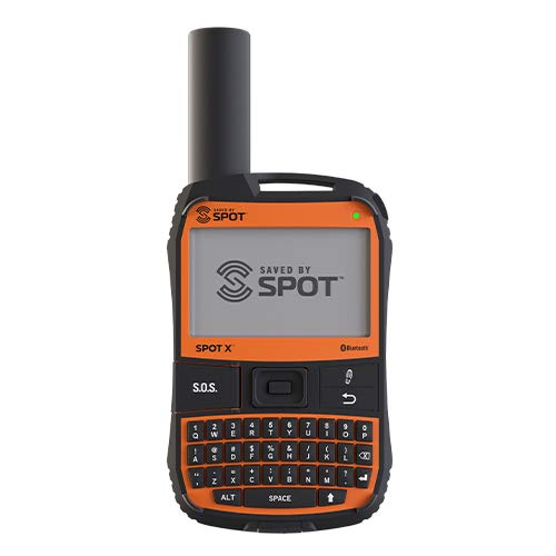
Spot X with Bluetooth 2
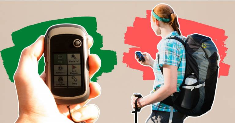
Hiking is one of the most popular outdoor activities. It is excellent for getting out in nature and enjoying it. Unfortunately, many people are also afraid of it. Hiking can be dangerous. It can be even more hazardous if you do not know where you are going or how to get there. To make your hike more enjoyable and less scary, you need hiking gear that helps you stay safe.
When planning your next hiking trip, you might wonder which GPS is best for hiking. After all, there are a lot of different models on the market today. Some of them are excellent for outdoor activities like hiking. Others, not so much.
It can be not easy to know which GPS to purchase and which ones aren't worth it. Luckily, we have researched for you and found the best GPS for hiking available today. Following extensive study and analysis, We think the best gps for hiking of 2026 is Garmin eTrex 10 Handheld GPS cause it is the first consumer-grade receiver that has ever been made to track GPS and GLONASS satellites simultaneously. However, it is not the only thing on our list. We also show a complete buyer's guide and various options available to help you find the most suitable one.
Our Top Picks

Easily track your progress and position with the built-in GPS receiver Store waypoints along a track for easy navigation View high and low elevation points for more accurate navigation Durable and waterproof construction for use in any weather condition
Comes with a basic feature set
The eTrex series is the first consumer-grade receiver that has ever been made to track GPS and GLONASS satellites simultaneously. Additionally, the eTrex can maintain its GPS location even when operating in dense cover or deep canyons. It conforms to the specifications of IPX7 for water resistance, making it resistant to water, such as rain, splashes, and so on.
The eTrex 10 is an excellent choice in handheld navigation for the frugal outdoor enthusiast who wants to get the most for their money. The high-sensitivity GPS receiver, 2.2-inch monochrome display, and worldwide base map that come standard with this particular model of eTrex make it simpler than ever before to keep track of where you are and where you have been. On the other hand, it is impossible to load additional mapping, and there is no SD card slot for expanding the memory. In general, if you're on a tight budget, this is still an excellent option.
Detailed information and geographical maps Button interface that is simple to use Options for many types of base maps Water-resistant
The battery can run out fast A separate subscription is required for some of the features
First and foremost, this product includes a crystal-clear screen that measures 2.31 inches and displays the birdseye satellite images in the form of precise color maps. Even though it cannot be worn, this handy device is nearly as powerful as the majority of smartphones available on the market today.
This device also provides you with even more functionality and convenience. In addition, Earthmate makes it possible for you to use all of the capabilities of inReach on the mobile device you have associated with. You may also link your inReach gadget with your phone's contact list to simplify sending messages. This will allow you to communicate with anyone, regardless of location, using fewer keystrokes. Anyone who enjoys getting away from it all, whether on land, water, or in the air, can use inReach to communicate with others, share their location, and access vital SOS capabilities.
Activation requires neither a phone nor the internet Bluetooth 2 lets consumers stay connected while traveling 2 AA batteries last ten days Durable and waterproof design for any adventure
The keys are small, and it may take time to type
When you travel beyond the areas covered by dependable cellular coverage, SPOT provides you with a vital and perhaps life-saving line of contact. To receive messages, you can use SpotX as a solo communication device with its unique US mobile number. Connect SpotX to your cellphone to contact relatives or even search and rescue personnel. It provides sophisticated tracking for the items that are most important to you. You can track SPOT Mapping with your mobile device or a computer.
The SOS function, available on the Spot X and the Spot Gen 4 devices, can send an alert to the GEOS International Emergency Response Coordination Center with your GPS coordinates and information to local teams who can take measures that could save lives. Everything can be done at the touch of a button. The only downside is that the keys are pretty small (even though it is a full QWERTY keyboard), so it takes slightly longer to type in messages than it does on a smartphone.
Compact and lightweight, making it easy to carry and transport Two-way messaging lets users communicate and share their location Interactive SOS will enable users to send emergency alerts and 24/7 emergency services worldwide
Requires a satellite subscription
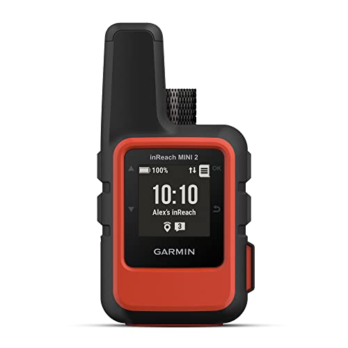
TracBack® routing directs you back to your starting place along the same path you took to get there, all on the device you were using. You may also let loved ones back home know where you are by utilizing the MapShareTM website you have created for them or by including your coordinates in the messages you send them. Even when you are standing still, the digital compass will provide you with precise information regarding your heading.
You can use the Garmin ExploreTM app to plan journeys, consult topographical maps, create waypoints and courses that you can sync to your device, and do much more on a smartphone that is compatible with the app. With a battery life of up to 14 days in 10-minute monitoring mode, you can enjoy your excursions much longer. Although the Garmin inReach Mini 2 does have communication features, to use them, you will need to pay for a subscription to the inReach service.
Durable and waterproof design 3-axis compass and barometric altimeter 8 GB of internal memory for map downloads Micro SD card slot Long battery life
The rechargeable option is not included
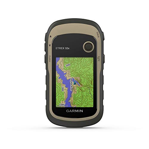
The handheld gadget eTrex 32x comes equipped with road-routable TopoActive maps containing streets and trails so you can take the excursion away from civilized areas. You can now become familiar with your surroundings, including buildings, canals, natural elements, and international boundaries, among other things. In addition, thousands of points of interest, such as shops, restaurants, universities, parking lots, and lodgings, may be found here.
Because the receivers in the eTrex series employ GPS and GLONASS satellite systems rather than just GPS, they can track in conditions that are more difficult to do so using GPS by itself. Adding a barometric altimeter and a three-axis compass to the eTrex 32x makes it much simpler to keep your bearings. The only drawback is that it does not come with a rechargeable alternative. In general, it is still an ideal tool in every respect.
Allows users to quickly and easily reach out to multiple contacts in non-emergency situations Customized message allows for personalization SMS and email capabilities provide flexibility in communication An optional subscription allows for regular testing of the GPS
The phone type is small, so it will be a bit hard to read
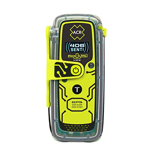
This product has the three satellite constellations that make up COSPAS-SARSAT and provide global coverage. They are the ones that are responsible for relaying your distress signal straight to various Search and Rescue organizations throughout the world. This eliminates the need for a rescue monitoring center. Using the optional 406Link testing subscription, you may send pre-canned, non-emergency self-test and GPS test messages to various contacts through text message (SMS) and email with a personalized message. These messages can be sent with a customized message. On the other hand, the font type is on the small side, which makes reading in bright sunlight more difficult than it would be on a smartphone.
After being engaged, the 406 MHz Emergency Distress Signal with a 121.5 MHz Homing Signal will transmit an SOS distress signal with the GPS location directly to search and rescue personnel worldwide. Multiple visual messages can be sent to those trying to help you if you have a powerful LED Strobe light and an Infrared Strobe light.
The rugged and waterproof build makes it outdoor-friendly High-resolution displays show maps and data clearly Connect IQ-compatible; users can add data fields, widgets, and apps Built-in GPS and GLONASS for navigation
Limited memory capacity
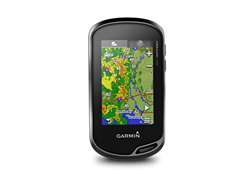
The Oregon 700 is a tough handheld GPS and GLONASS device that puts more of the great outdoors at your disposal. This is possible with a revised antenna that improves satellite reception in rugged and remote areas. Other advantages include support for the weather with animated radar overlays, enhanced wireless networking, and automated geocache downloads. This product also comes with a worldwide shaded base map, a 3-axis compass with a barometric altimeter, a dual-orientation 3-inch touchscreen, and a great deal more.
You can utilize the increased wireless capabilities to download software, obtain smart notifications, submit adventures to the Garmin link online community, and even share LiveTrack location data or geocache discoveries with other compatible devices on a unit-to-unit basis.
However, it can only hold 1.5 GB of data, so you need to purchase and utilize an additional micro SD card to download Garmin's maps.
More To Consider


What to Look For in a best gps for hiking?
You may know that best gps for hiking is a kind of product many customers are hesitant to pay for. It is not due to its quality but the fact that there are many factors you must consider. Nevertheless, all your worry is not a problem for us. Our knowledgeable staff will help you with the right decision.
Tech-evaluated and high-rated products are available in our list of eligible items. Here are some indispensable things you shouldn’t ignore:
Weight
Batteries
Screen
Durability
Route Recording
Planning Routes
FAQs
How Do I Enter The Destination?
On the screen, a keypad pops up as you type the address. You typically enter the address using predictive typing, but you can also enter the address from start to finish if you have already visited the location. You can speak the address or choose from your favorite and recent destinations, in addition to choosing from gas stations, hotels and medical facilities. The map typically includes businesses, museums, hotels, gas stations and medical services as well as street addresses.
Why Buy A Portable GPS Instead Of Using My Phone?
Many individuals use a phone for navigation. You can begin a journey anywhere with a portable GPS, a portable navigation device, or a dashtop GPS (same thing). A cellular signal is required to set up a trip and download map data on a smartphone; a portable GPS has maps built in. A 7.0-inch screen is typical on a portable GPS, bigger than most smartphones. Hands-free calling is available if you have an older automobile without Bluetooth. The microphone and speakers of a GPS device allow you to make phone calls without using a handsfree device.
Will My GPS Tracker Still Work In Rural Areas?
If you live in an area where cell service is patchy, then you're likely to experience spotty GPS behaviour as a result. It doesn't mean the GPS isn't working; it just means that it is unable to send the location information to your phone because there aren't enough cellular towers around to do so.
What are the benefits of using a GPS for hiking?
GPS devices can be a great asset for hikers. They can provide detailed maps of your route, help you keep track of your current location, and even allow you to mark points of interest for future reference. GPS devices can also provide safety features such as altitude tracking, emergency alerts, and access to search and rescue services in the event of an emergency.
What type of GPS should I use for hiking?
The type of GPS you should use for hiking depends on your individual needs and preferences. A handheld GPS device is a great choice for basic navigational needs, while a more advanced hiking watch or app can provide additional features such as preloaded trails, tracking of your current location, and even the ability to share your location with others.
What should I look for in a GPS device for hiking?
When choosing a GPS device for hiking, consider features such as its durability, waterproofing, battery life, accuracy, and the type of maps it provides. Pay attention to the size and weight of the device, as well as its user interface and ease of use. If you plan to use it for backcountry navigation, consider its ability to track altitude, navigate in areas without cell phone service, and access search and rescue services.
Can I use a smartphone for hiking GPS?
Yes, you can use a smartphone for hiking GPS. Smartphone apps such as Google Maps, Gaia GPS, and AllTrails provide detailed maps and navigation tools, as well as additional features such as preloaded trails and the ability to share your location with others. Be sure to bring a power bank as well, as smartphone batteries can quickly drain in the outdoors.
What is GPS used for in hiking?
GPS (Global Positioning System) is a satellite-based navigation system used by hikers to track their position, measure their distance traveled, and plan their route. It can also be used to help hikers find their way back to the starting point of the hike, or to the nearest point of safety should they become lost.
READ NEXT: The Best Portable Solar Charger For Camping In 2026
About Scott Nelson